

Brotkrumen-Navigation
Reiter
Funktionen
-
 schlauch | schlauch | 20. Jul 2021, 11:05
Bearbeitet am: 20. Jul 2021, 11:53 - durch schlauch | schlauchLesson 4: Digitalisation in 3DIn this thread you can post the answers to the excercises that can be found in the course unit in each of the 12 lessons.
The exercises consist of two components: the Definitions and the Tasks. Please post your answers to both parts.
The fourth lesson of this course can be found here. You can access the exercises belonging to the fourth lesson here.Beneath this post you will find some exemplary answers from previous semesters.
-
schlauch | schlauch | 20. Jul 2021, 11:06
Lesson 4: Digitalisation in 3DSanna Maria Urban
Task 1: In Sketchfab I have displayed the boxer from Rome as an example (https://sketchfab.com/3d-models/the-boxer-2016-1ce0340711854842822e4bf0146b1e1a). Metadata are given that contain the properties of the model, such as the file format (jpg), the file size (44MB) and the number of vertices (175.7k). Furthermore, information about the processing of the model can be given, e.g. the use of PBR (physically based rendering) of UV layers, vertex colours or rigged geometries, all of which were given as "No". Otherwise, no paradata can be identified. In the text, the creator mentions Sketchfab's PBR materials and rendering as a tool. Furthermore, he refers to an earlier model of this statue, which is less well detailed and textured, which can be easily understood when looking at it, since, for example, the scars on the face are not visible. However, further data on the creation and reworking process are not given. Thus, for the scientific consideration of this model, there is a lack of clues for assessing the closeness of the model to the original. Camera data, number of original photos and information on the exposure situation are missing.
Task 3: As I seem to have downloaded a newer version than the one used in the tutorial, there was no "Remove faces from non Manifold edges" under Cleaning and repairing. I used the command "Repair non Manifold edges by removing faces" for this and hope they do the same. I could reduce the faces to either 206,000 or 169,000 and guess that in that case it is better to work with 206,000 faces. -
schlauch | schlauch | 20. Jul 2021, 11:07
Lesson 4: Digitalisation in 3DDennis Cooper
Task 1: On Sketchfab, for the model 'Emperor Antoninus Pius', various metadata are given, including the file format, which here is .obj, and one can read various data about the 3D model. However, there is a lot of missing data, e.g. nothing about how exactly the 3D model was created, i.e. nothing about the camera that was used, about the lighting conditions, or about the software that was used to create this 3D model. Therefore, it is unfortunately not suitable for our needs.
-
schlauch | schlauch | 20. Jul 2021, 11:08
Bearbeitet am: 20. Jul 2021, 11:11 - durch schlauch | schlauchLesson 4: Digitalisation in 3DJohanna Plath

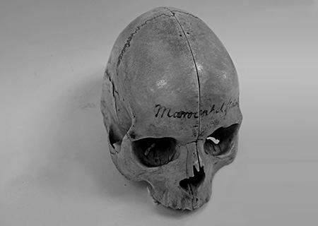
Source: https://sammlungen.uni-goettingen.de/api/v1/cms/media/files/anatomie-titel.jpg/full/max/0/default.jpg?updated=2017-11-08T15:44:57.222708ZI would document the skull by means of photogrammetry, because it is mainly about the anatomical condition and less about the smallest traces of e.g. transport. Moreover, this method is quick and easy to implement. It seems that the skull can be taken apart to look inside. However, if this is not possible, a CT scan could be used. In this way, it could be found out whether the individual had a frontal sinus or not. If the skull showed traces of a disease, the CT would be all the more exciting in order to be able to make statements about the changes in the skull bone. Since this skull comes from Blumenbach's skull collection, it could perhaps be placed on the table in his office in our project, where he once examined any skulls for his dissertation.
-
 karim.dietrich | karim.dietrich | 03. Nov 2021, 12:44
Lesson 4: Digitalisation in 3DKarim DietrichDecimation – the act of reducing the number of faces or polygons on a 3D model. This will reduce the size of the filebut also the qualitiy of the model. It is a part of the postprocessing of 3D scans.
Task 4.3:
-

-
 Elvis24 | Elvis24 | 30. Jan 2022, 18:49
Digitalisation in 3D_Elvis SongwaDefinitions
- Ortho-Photography: the art of taking and processing aerial images that has been geometrically corrected (ortho rectified) so that the image is uniform from edge to edge.
- (Archaeological) Hand Drawing : a style of drawing made without the use of guiding or measuring instruments.
- 360° photo series : is a 2D digitisation technique when all-round shots with a certain overlap are put together in such a way that the eye thinks it is moving spatially. This is done with the help of the stitching technique.
Reflectance Transformation Imaging (RTI): is a two-dimensionalvisualisation technique in which a series of photographs are created under changing lighting conditions, mostly used in the acquisition of cultural heritage.
- Stereovision: is a 2 dimensional visualisation technique where two cameras take photos of the same scene, but separated by a small distance
- Stereoscopy: is a technique used to enable a three-dimensional effect, adding an illusion of depth to a flat image.
- Acquisition: is the measurement of 2D or 3D data by scanning, photographing, photogrammetry, tomography or any other surveying technique.
- Triangulation: is an old mathematical method, already known to Thales, by which a curved surface is broken down into triangles that can be easily calculated. Simply put as the generation of points and triangles to describe a geometric body.
- Structured-Light-Scan: a process where a kind of beamer projects a structured, spatial fringe pattern onto the object.
- 3D Model: is a mathematical representation of the surface of an object in three dimensions. It therefore consists of a collection of points in 3D space connected by various geometric entities such as triangles, lines, curved surfaces etc.
- Construction of a 3D model: is the use of computer programmes or software to create or supplement three-dimensional models of the objects.
- Point cloud: a disorganised spatial structure of points, or better a simple list of 3D vectors between which there is no connecting structure.
- Vertex: is a corner or node point, i.e., a point where several directions meet.
- Mesh: a list of 3D polygons that represents a set of connected vertices.
- normals of a 3D point: object such as a line, ray, or vector that isperpendicular to a given object.
- Vertex-Colour: colour values applied directly to vertices in meshes
- Albedo: is the measure of diffuse scattering power of different materials and is used for simulations of volume scattering.
- Texture: is a 2D image that is used to clad a part or an entire object.
- Texel: is a pixel of a 2D texture
- Computer tomography: is a medical imaging technique that uses a computer to generate digital cross-sectional images of physical objects based on X-ray signals.
- Photogrammetry: the use of photography in surveying and mapping to measure distances between objects.
- Computer Aided Design (CAD): is the use of computers to aid in the creation, modification, analysis, or optimization of a design. A complete construction drawing ex novo on the screen.
- Decimation: is reducing the number of polygons.
- Georeferencing: is the positioning and geographic orientation of 3D models without modifying the original source data.
- Processing (of a 3D model): is the scientific intervention in a 3D model starting from the initial structured model and all resulting processed models, including filling holes or post-processing the texture.
Task 4.1.The search for "ancient sculpture" in the page https://sketchfab.com resultes on some artefacts where a very few data are provided: number of triangles, vertices and download size. To be used in a scientific work, a great amount of data is still necessary: PBR, texture, materials, UV layers, vertex colours, resolution, animations and rigged geometries are missing. Too, the digitisation process followed is unknown.
Task 4.2.Since my project is about the live of nobel prices related to the city and/or the University of Goettingen, I have chosen the object under the link https://sammlungen.uni-goettingen.de/objekt/record_kuniweb_1109355/1/-/, belonging to Otto Hahn, Member of the Academy of Sciences (1924), President of the Max Planck Society (1946–1960), signatory of the Göttingen Declaration (1957), died and buried in Göttingen (1968), nobel price in chemistry in 1944 (source of information: https://second.wiki/wiki/gc3b6ttinger_nobelpreiswunder).
The digitisation process I would use to record is the 3D Construction or Computer Aided Design (CAD), because a) it can used to create 3D models of objects on the basis of photographs (our current object is a 2D photograph), b)the existent technologies makes it easier, c) the resulting model can contain geometric, volume and material properties, and d) the output file is low sized, which makes it suitable to be used in virtual environments. In our Timemachine, this object could be placed inside the 3d representation of Otto’s laboratory.
-
 sahar.t6889 | sahar.t6889 | 07. Mai 2024, 12:50
Lesson 4: Digitalization in 3D-Ortho-Photography: a standardized method in photography in which the camera is placed both vertically and horizontally and parallel to the surface of the object
- (Archaeological) Hand Drawing: a technique in archaeology to record artifacts which is prevalent due to simplicity and attention to the variation of details as opposed to computer aided design
- 360° photo series: using a stitching technique, the shots are put together with certain overlap and the eyes think it is one photo which is moving spatially
- Reflectance Transformation Imaging (RTI): it is a technique that is used to take the surface of an object in details in a way that two-dimensional photos are taken under different lighting
- Stereovision: two cameras take phots from one scene with a small distance, and then an algorithm makes these two as one and superimposes them.
- Stereoscopy: a technique to create the illusion of three-dimensional depth from 2 flat images
- Acquisition: measuring 2D and 3D data by scanning, photographing, and other techniques
- Triangulation: a mathematical method to calculate the surface of a curved object by dividing it to small triangles
- structured-Light-Scan or white light scanner refers to those scanners which use structured light with the help of a projector which casts the pattern of lines onto the object
- 3D model: representing the surface of an object in three dimensional in a way that the scanner makes a number of points with their attributes such as geometrics, color,…that are connected
- Construction of a 3D model: constructing the surface of an object in 3 dimensions
- Point cloud: a disorganised spatial structure of points / mapping the geometry of a physical object / a list of 3D polygons, that is, the connected vertices
- Vertex: the corner of a polygon / points where the dimensions meet
- Mesh: point cloud
- normals of a 3D point: a vector that is orthogonal to another line or a curve or a plane
- Vertex-Color: the colors that are applied to vertices in a mesh
- Albedo: how much light a material scatters when light hits it
- texture: the color information and the visual surface detail that is stored in an image file to specify how the surface of a 3D object should look alike
- Texel: the pixels of a 2D texture / the individual elements of 2D images
- Material (of a 3D model): the optical properties like reflection, transparency, and specularity which are stored in a material file of the 3D image
- Computer tomography: the image technique that uses x-ray signals to take images which is particularly useful when taking a photo from the inside of an object
- Photogrametry: measuring the distance between objects using photography
- Computer Aided Design (CAD): using computer programs to make 3D models of an object based on its 2D drawing
- Decimation: the process of reducing the number of polygons in 3D modeling, however, a validation process is important to make sure this decimated model has all the important details are retained
- Georeferencing: Georeferencing is the act of placing 3D models accurately within a standardized geographic coordinate system without changing the original data
- Processing (of a 3D model): any scientific intervention in a 3D model such a filling holes or processing the texture
- Semantic enrichment: an interpretation of the acquired data and which is often necessary for understanding the object of study -
 AnahitaFouladvand | AnahitaFouladvand | 07. Mai 2024, 20:45
Lesson 4task 1
1. Ortho-Photography: A photography method where the camera is positioned parallel to the object's surface, both vertically and horizontally, following standardized procedures.
2. (Archaeological) Hand Drawing: An archaeological technique for documenting artifacts by hand, valued for its simplicity and ability to capture nuanced details compared to computer-based design methods.
28. Shader: A program used in computer graphics to determine the rendering properties of surfaces, such as their color, texture, and lighting effects. Shaders are commonly used in rendering engines to simulate the interaction of light with objects in a scene.
3. 360° photo series: A series of photos stitched together to create the illusion of a seamless, spatially moving image, achieved through overlapping shots.
4. Reflectance Transformation Imaging (RTI): A technique capturing detailed surface information of an object through multiple two-dimensional images taken under varying lighting conditions.
5. Stereovision: Utilizing two cameras to capture a single scene from slightly different perspectives, which are then combined using algorithms to create a unified, stereoscopic image.
6. Stereoscopy: A method of producing a three-dimensional effect from two flat images.
7. Acquisition: The process of gathering both two-dimensional and three-dimensional data through scanning, photography, or other methods.
8. Triangulation: A mathematical approach to estimating the surface of curved objects by dividing them into smaller triangles.
9. Structured-Light-Scan or white light scanner: Scanners employing structured light patterns projected onto objects using a projector to capture detailed surface information.
10. 3D model: A representation of an object's surface in three dimensions, generated by scanners that capture points with attributes like geometry and color.
11. Construction of a 3D model: The process of creating a three-dimensional surface representation of an object.
12. Point cloud: An unordered collection of points mapping the geometry of a physical object, typically forming a set of connected vertices.
13. Vertex: A point where edges meet in a polygonal mesh.
14. Mesh: A collection of vertices, edges, and faces forming the surface of a 3D object.
15. Normals of a 3D point: Vectors perpendicular to a surface, line, or curve in three-dimensional space.
16. Vertex-Color: Colors assigned to vertices within a mesh.
17. Albedo: The measure of a material's diffuse reflectivity, indicating how much light it scatters when illuminated.
18. Texture: Visual surface detail and color information stored in an image file to dictate the appearance of a 3D object's surface.
19. Texel: Individual elements or pixels of a 2D texture image.
20. Material (of a 3D model): Optical properties such as reflection, transparency, and specularity stored in a file associated with a 3D image.
21. Computer tomography: An imaging technique utilizing X-rays to capture internal images of objects, particularly useful for imaging the interiors of solid objects.
22. Photogrammetry: Measuring distances between objects using photography.
23. Computer Aided Design (CAD): Utilizing computer software to create three-dimensional models based on two-dimensional drawings.
24. Decimation: The process of reducing the number of polygons in a 3D model, typically requiring validation to ensure important details are retained.
25. Georeferencing: Accurately placing 3D models within a standardized geographic coordinate system without altering the original data.
26. Processing (of a 3D model): Any scientific manipulation or enhancement of a 3D model, such as filling holes or refining texture.
27. Semantic enrichment: Interpreting acquired data to enhance understanding of the object being studied.
29. Consolidation: In the context of 3D modeling or data processing, consolidation refers to the process of combining or merging multiple elements, such as vertices or polygons, to simplify or optimize the model while preserving its overall structure and details. This process helps reduce complexity and improve the efficiency of rendering or manipulation. -
AnahitaFouladvand | AnahitaFouladvand | 07. Mai 2024, 21:17
Lesson 4Task 2
I am interested in the image of Lamassu.
The paradata is:
The metadata which is documented:
Title, Creator, Description, Tags, Date of Creation, Dimentions, Historical Source
nothing has been said about the procedure and the softwares which has been done and used to create the image.
This type of data is not determined. The only information that can be derived is that since the original Persian statue is damaged, the creator used the Assyrian Lamassu as a base. -
sahar.t6889 | sahar.t6889 | 14. Mai 2024, 10:09
Lesson 4: Digitalization in 3DTask 2
I chose the Terracotta goddess sculpture since it is a Persian goddess on Myminifactory website. Regarding the metadata, the name of the sculpture has been provided by the designer, as well as a very short description. However, it might be too short and a bit uninformative. The size of the original statue,the period it belonged to, and the location where it is exhibited now have been mentioned. You can also see the date of the creation of this model and the licence under which ths model was created. Concerning the paradata, nothinh has be provided by the creator. In other words, no information regarding the material of the object, the software that was used to create the model, or the limitations and problems that the creator was confronted with while making the model is mentioned.
